Arizona's White Mountains
|
Elevation: 8,600 to 8,840 foot. |
Season: April through November, depending on snowpack.
|
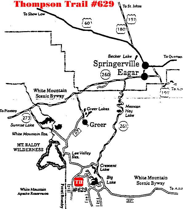
Access: The trailhead is on F.R. 116 by the
confluence of Thompson Creek and the West Fork of the Black River. |
|
Length: 6.5 miles round trip. |
Difficulty: Moderate. |
Use: Moderate |
Description: The Thompson Trail follows the course of the
West Fork of the Black River and passes through some of the most striking
country to be seen on the Springerville District.
This high country,
snowed in for nearly half the year and characterized by steep, timbered canyons
and frequent meadows. The Thompson Trail takes you through this and more. Add a
shallow fast moving stream that is a nationally recognized Blue Ribbon fishery
and you have an idea of what awaits you on trail #629.
The trail
begins just off Forest Road 116 near Thompson Ranch. Because it travels
alongside of the West Fork of the Black River the trail is generally level.
Some stretches of the trail pass through boggy ground. For this reason, horses
and bicycles are not allowed, but foot travel is. When the water is high expect
to get your feet wet while traversing these sections.
An old railroad
bed is located upslope from the trail and the river. Feel free to hike, bicycle
or ride a horse on the cindered railroad bed. The rail road bed follows the
route of the trail pretty closely and offers the same great scenery.
As you walk along the first mile or so, you will notice large piles of rocks
secured in wire (gabions) that span the width of the creek. These are fish
barriers, designed to allow fish to swim downstream but not up stream. Thus,
the upper reaches of the river and its tributaries are free of exotic,
non-native trout.
Attractions and Considerations: This trail connects with
the West Fork Trail #628 and loop trail #628A. The
trail is open to foot travel only. If you wish to ride a bicycle or horse you
may use the old rail road bed which runs parallel to the trail and is located
upslope from the trail. Horses are prohibited on Trail #628. No motorized
vehicles are permitted. Please stay on the trail and avoid making shortcuts.
Bring drinking water or a purification system. The stream water is not treated.
The Thompson Trail was built with a grant from the Heritage Fund in cooperation
with the U.S. Forest Service and the Arizona Game and Fish Department. The
trail was constructed with help from many volunteer organizations.
For more information, please feel free to contact
the USDA Forest Service, Springerville Ranger District at 928.333.4372 or you
may write us at 309 S. Mountain Avenue, Springerville, Arizona 85938
White Mountains Online wishes to express our
appreciation to the USDA Forest Service, Springerville District for providing
this information! Page Design & Graphics by White Mountains Online.
Copyright © 1999. All rights reserved. |