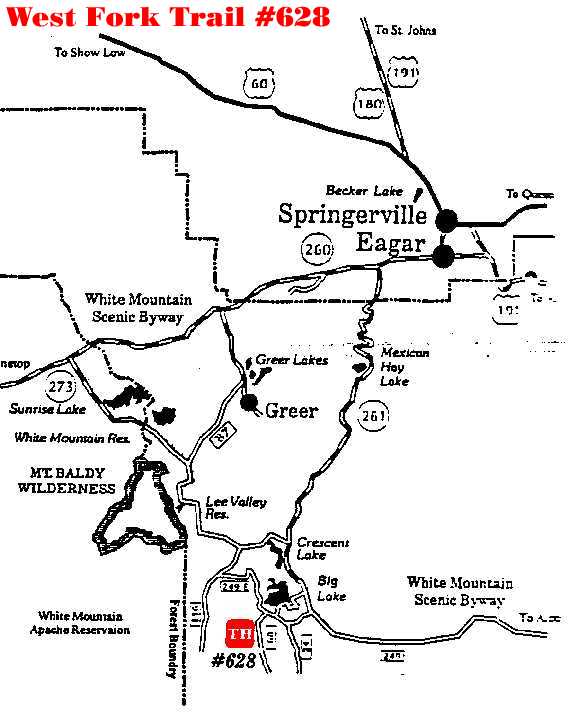
West Fork Trail #628
Arizona's White Mountains
Description: The trail begins on a fairly level grade and
takes you through stands of Douglas-fir, ponderosa pine and aspen, with some
grass meadows thrown in for variety. A few rolling hills dominate the first 2.5
miles, then the trail drops down to the Black River drainage. This portion of
the trail is very steep, which should present little problem to hikers but
mountain bikers may find it difficult. In the words of an enthusiast, "If you
ride it down, you have to pack it up." Before dropping down, the trail follows
the canyon rim, offering magnificent views of the river. About halfway down
slope, you will come to a rock slide with a rustic bridge spanning it. As you
prepare to cross, pause a moment and listen. Deep beneath the rocks you can
hear the distinct sound of a spring bubbling. From the bridge, it is a short
way to the river. Attractions and Considerations: This trail does not go to the West Fork Campground. This trail was built specifically for hiking and mountain bicycle use. To avoid user conflict, it is closed to horseback riding and motorized vehicles. The West Fork Trail is connected to both the Thompson Trail (#629) and the Indian Springs Trail (#627). Parking is available at either trailhead. The black rubber bars set across the trail are water bars, designed to carry runoff away from the trail to prevent erosion. It is safe to ride over on a bicycle. Only experienced mountain bikers should attempt the portion of the trail that descends to the Black River, as it becomes very steep. Bring drinking water, as water sources in the area are untreated.
For more information, please feel free to contact the USDA Forest Service, Springerville Ranger District at 928.333.4372 or you may write us at 309 S. Mountain Avenue, Springerville, Arizona 85938White Mountains Online wishes to express our appreciation to the USDA Forest Service, Springerville District for providing this information! Page Design & Graphics by White Mountains Online. Copyright © 1999. All rights reserved.
|