| Arizona White Moutains |
MOUNTAIN STREAMS.
| P - Q - R - S - T - U - V - W - X - Y - Z  |
|
Black River: |
( West Fork): Length: 8 miles. Elev. 6,520 to 7,525 ft. Access from same as the East Fork, continuing on FR 25 to Wildcat Point. This section of the Black River is more difficult to reach but offers an excellent example of Arizona's beauty with grassy meadows and tall pines. The area to the reservation border is brushy and weedy, but there's always the possibility of catching lunker browns in hiding pools. Wildlife sights include elk, turkey, and bear. |
Black River:
|
(reservation border to White
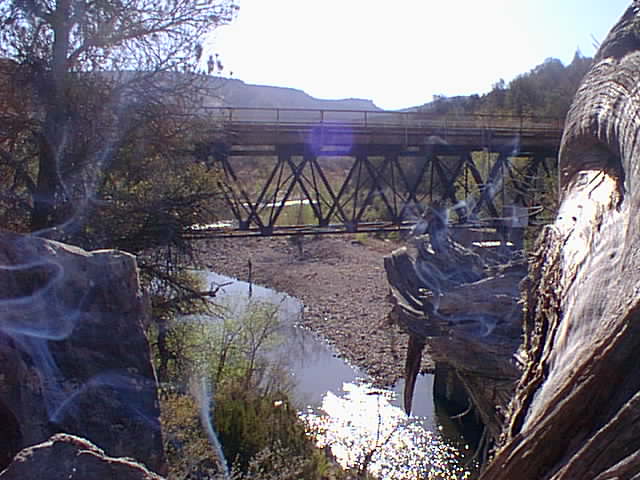
River): Length: 45 miles. Elev. 4,400 to 6,520 ft. Access from Fort Apache south on Y10 to the river or using Y20, Y22, or Y40 to points farther east on the river. Better bring the four-wheel-drive. This lower elevation stretch of the Black provides for some excellent smallmouth bass and catfish, with trout at higher elevations. May through July is the best time for bass. Walk up and down the river past the road accesses for the best fishing. Don't forget the permits at San Carlos or Fort Apache Game and Fish vendors. Either permit allows anglers to fish both sides of the Black. However, be careful to camp on the appropriate site. The lower elevations get into the scrubby prairie vegetation and chaparral. |
Black River: |
(East Fork): Length: 8
miles. Elev. 7,525 to 7,900 ft. Access north of Hannagan Meadow at
Beaver Creek; and from U.S. 191 and FR 26 along Beaver Creek; or from
U.S. 191 to FR 249 and FR 276 to the Black River. This is one of the
most beautiful stretches of the Black River with the high elevation
vegetation and wildlife including: elk, bear, and turkey. The river is
stocked weekly in the summer with rainbow trout, but watch out for
beaver dams. Campgrounds, located at Buffalo Crossing and at points
farther upstream, are open during the summer. Winter access is not
recommended.
|
Blue River:
|
Length: 24 miles. Elev.
4,200 to 5,250 ft. Access from Alpine and west on U.S. 180 to FR 281
and south on FR 567, between Alpine and Hannagan Meadow, east to Blue
Crossing. The road follows the river south. Watch for and respect
private property signs. The roads down into the Blue River canyons
provide excellent views of eastern Arizona beauty. At the bottom lies
the community of "Blue," which still has a post office and a few
ranches. The old schoolhouse that stood for many years burned down a
few years back. Only a good snow melt and runoff provide the Blue
River with its water flow. Anglers may find some trout in the upper
reaches, but past Blue Box there may be just a few catfish in the
pools. Campers can set up at two established sites (Upper Blue or Blue
Crossing) or at the primitive grounds at the end of FR 281.
|
Big Bonito Creek: |
Length: 11 miles. Elev.
5,250 to 7.000 ft. Access by reservation roads Y55, Y40, and Y70,
southeast of Fort Apache. Hike or backpack down to the creek. Big
Bonito Creek flows through the Bonito Prairie. Bonito is the Spanish
word for pretty. The canyon walls are filled with oak, willow, and
cottonwood trees. Cool, clear waters spill over the rocks into the
pools of brown and rainbow trout. The area has spectacular beauty and
many hunters come during the seasons for mountain lion, bear, and
javelina. Special permits from the White Mountain Apache Tribe are
required, so remember to stop in Whiteriver on the way to Big Bonito
Creek.
|
Boneyard Creek: |
Length: 9 miles. Elev.
8,000 ft. Follow FR 249 north of Alpine off U.S. 191. Boneyard Creek
is just north of the Black River (East Fork) crossing. Boneyard is
just a small creek with small rainbow and brook trout. Primitive
camping is allowed. There are more of these smaller creeks in the
vicinity of Hannagan Meadow, but fish of any size are doubtful. These
streams are nice picnic areas or photo subjects, though.
|
Canyon Creek: |
Length 31 miles. Elev. 2,905 to 5,300 ft. One approach to Canyon
Creek is through the White Mountain Apache reservation to Cibecue,
then take Route 021 past Grasshopper. Canyon Creek also is accessible
from the Mogollon Rim, from SR 260 and Young Road (SR 288). Flowing
from the top of the Rim, Canyon Creek finally deposits its runoff into
the Salt River, west of Salt River Canyon. Canyon Creek is undoubtedly
one of the best trout fishing streams in the state. The Arizona Game
and Fish Department stocks fish in Canyon Creek where it runs through
the National Forest. In these upper reaches of the creek, anglers must
fish with artificial lures only. North of Grasshopper, named for an
Apache scout, is Chediski Lookout and Mountain, which climbs to 7,500
feet. Permits are required for fishing and can be obtained at the Salt
River Store or Tempe Marine. |
Cibecue Creek: |
Length: 20 miles. Elev.
3,136 to 5,680 ft. Two accesses to Cibecue: one is north from the town
of Cibecue on Route 020; the other is from the Salt River Canyon road
G1. Entirely on the reservation, Cibecue Creek is stocked with Apache
trout north of the town toward the Rim. Some of the biggest browns in
the state have been pulled out of the pools of Cibecue Creek. In the
lower stretch, nice pools and waterfalls can be found by walking
upstream from the Salt River. Obtain fishing and day-use permits at
Salt River Canyon Store or Tempe Marine. Return to Top |
Diamond Creek: |
Length: 11 miles. Elev. 5,600 to 7,500 ft. Access by SR 73 between
Whiteriver and Hon Dah to RR25 on the White Mountain Reservation. This
beautiful creek in the White Mountains is home to rainbow, brown, and
Apache trout. Apache trout are stocked regularly. Check with the
reservation game and fish office regarding fishing regulations.
Permits can be obtained in Whiteriver or Hon Dah. The eastern branch
of Diamond (called Little Diamond) may have some small trout, but some
of this area is closed to non-Apaches. This high elevation area
combines grassy meadows, tall spruce and fir, with stands of aspen and
ponderosa pine. Wildlife sightings include deer, elk, and bear. Return to Top |
Eagle Creek: |
Length: 48 miles. Elev. 3,250 to 5,450 ft. Eagle Creek is best
approached on FR 217, north of Morenci off U.S. 191. The road winds
down a scenic canyon to a number of ranches and then follow the creek
upstream to Honeymoon campground. Depending on the water levels, Eagle
Creek can be good fishing for trout in the northern section. Other
wildlife sights are bighorn sheep and rare varieties of large birds
such as peregrine falcon, wintering bald eagles, and Mexican black
hawks in the lower section. Part of the creek runs through San Carlos
Apache Reservation, so permits are required. Return to Top |
Grant Creek: |
Length: 10 miles. Elev. 7,000 to 9,000 ft. Access by
hiking trails on the east side of U.S. 191 from Hannagan Meadow (#65)
or by way of Blue River, past Blue ranger station using FR 281. There
is a trail that follows the creek upstream (375) toward Hannagan
Meadow. Grant Creek provides a natural landmark for hikers more than a
source for anglers. There are a few small rainbows and some native
trout.
|
KP Creek: |
Length: 10 miles. Elev. 7,000 to 10,000 ft. KP Creek heads up on
the Mogollon Rim, runs along the Blue Range and finally down into Blue
River. Access south of Hannagan Meadow at KP Cienega Campground, off
U.S. 191. A northern fork heads up a few miles north of the
campgrounds. Follow trails #93 or #70. KP Creek has some native trout
and a few wild rainbows.
|
Little Colorado River: |
Length: Varies. Elevation 7,000 - 9,000 Ft. This river
was originally called Flax River be early Spanish explorers because of
the abundance of wild flax growing along its banks. The East Fork is
about six miles of very narrow creekbed and flowing water from Colter
Reservoir to Greer. Just a few small brookies and rainbows swim here.
The West Fork begins atop Mt. Baldy and flows north of Lee Valley to
Sheep's crossing on into Greer. In the upper reaches you'll find a few
brook trout; and around Greer a few small browns. The South Fork runs
north, just east of Greer and flows into the main tributary. There's a
campground and cabin resort at South Fork (FR 560) and hiking trail
#97 takes you back upstream. The area around Greer is quite impressive
with its rolling meadows, wildflowers and forests
|
Pacheta Creek: |
Access at Pacheta Lake using Y-55 and Y-40. Walking up
and down the shoreline is the best way to fish this small creek. The
stream may be pretty brushy in some places. Pacheta isn't stocked, but
some fish move from the lake and there are some natural spawners. This
is some of the most beautiful and remote country of Arizona. |
Paradise Creek: |
Length: 3 miles. Elev. 7,500
ft. There are good campsites below the confluence of Paradise Creek
and White River. Paradise Creek is open for fishing the first 3 miles
southeast of the junction of the North Fork of White River, just
downstream from
Ditch Camp.
Small and brushy and often difficult to fish, it is stocked by White
Mountain Apache Game and Fish during summer. Return to Top |
Reservation Creek: |
Length: 15 miles. Elev. 7,000 to 10,000 ft. Access
from Reservation Lakes south on road Y20 on the White Mountain Apache
reservation. Flows parallel to Pacheta Creek before reaching
reservation border, then on to Black River. Levels vary along this
wooded creek. Catches consist of brown, brook, and rainbow - all
fairly small, wild trout.
|
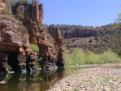
Salt River:
|
Length from Salt River Canyon to Gleason Flats: 20 miles. Elev.
2,840 to 3,350 ft. Access by reservation road G1 just north of the
bridge. Follow it east to Salt Flats. May require four-wheel-drive
vehicle. The mighty Salt River, with its whitewater rapids and
torrential flow, challenges kayakers and rafters with even the most
experience. If you don't have the skills to conquer this section of
the Salt, seek out one of the tour operators that plan trips down the
river. The Salt begins with the waters of the Black and White Rivers
flowing together about 35 miles upstream. One side of the Salt River
Canyon is on White Mountain Apache land; the other side is San Carlos
Apache Reservation. Permits are required from the reservations to
enter the land. Beautiful canyons, winding side streams and abundant
wildlife best describe the Salt River. There are smallmouth bass and
catfish in addition to various species of rough fish in the Salt.
Facilities include primitive camping at Mule Hoof, near the bridge. |
Silver Creek: |
Length: 1-2 miles fishable.
Elev. 6,500 ft. Accessible north of Show Low on U.S. 60 and FR 918
just past turnoff to Silver Creek Estates. Rainbow trout are stocked
by Game and Fish in the spring. Some very large native spawners have
been caught from this stream in early spring as they move up out of
White Mountain Lake and below the private hatchery at Silver Springs.
After about May, Silver Creek is too warm for good fishing. Early
settlers who built homes along the creek named it because it was
"clear and silvery."
|
Tonto Creek: |
Length: 16 miles. Elev. 5,700 to 7,800 ft. Accessible
from Y40 by taking Y47 north for four miles. Not to be confused with
the major Arizona stream in Gila County that runs from the Mogollon
Rim to Roosevelt Lake. Tonto Creek runs from Tonto Lake on the White
Mountain Apache Reservation to Bonito Creek. Fishing is generally
better lower on the creek. The stream has brown, rainbow, and Apache
trout. |
Trout Creek: |
Length: 15 miles. Elev.
7,500 ft. Trout Creek is accessible from Upper Log Road (via SR 73
south of Hon Dah) where it flows underneath the road and empties into
the North Fork of the White River. Another access point is at Hawley
Lake as it heads up to the northwest. This small stream has some
pan-size rainbow and brook trout in the short distance between these
two access points. Some lucky angler may come up with a big brown
lurking in the pools. A favorite stream of the serious dry fly
fisherman. Return to Top |
White River:
|
(North Fork): Length: 50 miles. Elev. 5,000 (south of
Fort Apache) to 6,800 ft. Best access to the upper reaches of North
Fork is by using Upper Log Road or the Roberts Ranch turnoff. Other
popular access points are the McCoy Bridge off SR 473, south of SR
260. The North Fork and East Fork of White River join at Fort Apache
to form the White River, which flows into what was the Black River,
creating the Salt River. Early reports tell that the river was called
Sierra Blanca River (or White Mountain River). This most popular White
Mountain stream is fished in heavy numbers and is a major draw for
camping and picnicking families. The Apaches stock it twice a week
throughout the spring and summer, plus there are many native spawners.
Apaches and brown are the best catches in the upper reaches. In the
section below Whiteriver and Fort Apache, smallmouth bass and some
catfish can be found. |
White River: |
(East Fork): Length: 6
miles. Elev. 5,000 to 6,500 ft. Driving south from Whiteriver on SR
73, turn east toward Fort Apache. This road crosses the river and
turns into Y55, which parallels the East Fork up to the closed area.
Much of the East Fork is in an area closed to non-Apaches. This is to
provide an undisturbed environment for the spawning of Apache trout.
Below R30, the river is stocked with Apache trout. It is mostly a
put-and-take stream, with some lurking lunker browns. Excellent
bird-watching opportunities abound. You might catch sight of
vermillion flycatcher or painted redstart. Return to Top |
| Information courtesy:
Pinetop-Lakeside Chamber of Commerce &
Arizona Department of Game and
Fish Fishing information |
|
| Greer & Springerville Trails Pinetop-Lakeside Trails |
|