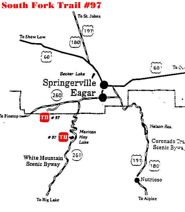
South Fork Trail #97
Arizona's
White Mountains
Description: Cool water, great view and three seasons of
use make the South Fork trail one of the most rewarding trails on the District.
A round trip hike adds up to fourteen miles so many people like to leave a
vehicle at each trailhead. The lower trail follows the South Fork of the Little
Colorado of 3.5 miles, through stands of cottonwood, sycamore, pine, aspen and
oak. Several grassy meadows open up the scenery and make ideal picnic spots,
offering a change from the steep-sided canyon that dominates most of the lower
trail. Attractions and Considerations: The primary trailhead is located in the South Fork campground on the west side of the creek. Parking is limited at this time. Please do not park in an occupied campsite. Another trailhead is located on the north side of Mexican Hay Lake. The roads to that trailhead can be very muddy during the spring run-off and the summer rains. If this is the case, park by the gate near the highway and walk to the trail-head. The trail is open to horseback riders, bicyclists and hikers.
For more information, please feel free to contact the USDA Forest Service, Springerville Ranger District at 928.333.4372 or you may write us at 309 S. Mountain Avenue, Springerville, Arizona 85938White Mountains Online wishes to express our appreciation to the USDA Forest Service, Springerville District for providing this information! Page Design & Graphics by White Mountains Online. Copyright © 1999. All rights reserved. |