Arizona's White Mountains
|
Elevation: About 9,000 feet at the trailhead. |
Season: All year. The trails are used for cross country
skiing in the winter. |
Use: Moderate |
|
Length: Variable. The shortest loop is slightly more than
1 mile, the longest is 6 miles. The entire complex of trails and roads runs for
almost 30 miles. |
Difficulty: Easy to moderate. |
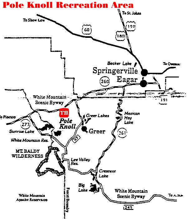
Access: Pole Knoll is located to the south of AZ
260, about 14 miles west of Springerville/Eagar. |
Attractions and Considerations: The Pole Knoll
Recreation area is primarily known as a cross-country ski area, but the trails
accommodate other activities through the rest of the year.
Most of
the trails are old roads. Some are closed to vehicular traffic, others are not.
Closed roads are signed. This is the only developed trail system on the
Springerville Ranger District with a varied use mix. That is, hikers,
bicyclists, horseback riders, motorized vehicles, may all find themselves on
the same trail. With this mixture of users, it is essential that each person
respect the rights of others.
There are two trailheads; the main one
is located just off AZ 260 and provides parking for up to 20 vehicles. In
addition to parking, outhouses (during the winter months) and an information
board are set up. The secondary trailhead is located off AZ 373, north of
Greer. Parking is available for 6 to 8 vehicles and an information board is
there. No overnight camping is allowed in the parking areas.
The
trails are signed with Nordic ski symbols. You might not think these will be
very helpful in the middle of July, but what goes for skiing often goes for
walking and even riding a bicycle as well.
- A Green circle means an easy trail.
- A blue square indicates a moderately difficult trail.
- A black diamond advertises the most difficult Pole Knoll has to
offer.
Description: Pole Knoll is very typical of the
knolls that grace the White Mountains. The north side is heavily timbered with
spruce, fir and aspen. The west and south aspects are mainly bunch-grass, with
some mixed conifers toward the top. The east side of the knoll is a mixture of
ponderosa pine, spruce, fir, aspen and even a few hardy oak trees.
Trails and roads provide access to most sections of the knoll. Motor vehicles
are limited as to where they can go, but for those using muscle-power or
horses, the only limiting factors are energy and daylight. The trail system
covers all terrain found on the knoll. Vehicles are prohibited from the fragile
grass slopes and also the recently built trails in the forested areas. Please
obey all road closure signs, there are enough roads without making new ones.
Each trail has been given a name. The trails originating from the
Pole Knoll side are descriptive names and the names of birds and animals. The
trails originating from below, near Greer, have been given numbered
designations. Pamphlets describing the trails are available at the sign-in
register at each of the trailheads. Please return the pamphlet when you are
through so that others might use it.
The Pole Knoll area offers
fantastic views of the White Mountains, both in the distance and close up. Keep
your eyes to the ground and you may see wildflowers, mushrooms and animal
tracks. Look up and you can see Sunrise Lake, Sunrise Peak and Mt. Baldy
stretched out to the southwest, Green's Peak to the north and the Little
Colorado Basin to the East.
For more information, please feel free to contact
the USDA Forest Service, Springerville Ranger District at 928.333.4372 or you
may write us at 309 S. Mountain Avenue, Springerville, Arizona 85938
Page Design & Graphics by White Mountains
Online. Copyright © 1999. All rights reserved. White Mountains Online
wishes to express our appreciation to the USDA Forest Service, Springerville
District for providing this information! |