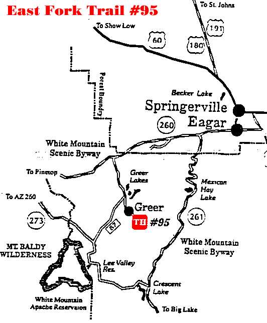
 East Fork Trail #95 East Fork Trail #95Arizona's White Mountains
|
Elevation: From 8,200 to 9,300 feet. |
Season: May through October depending on the weather.
|
Use: Light to Moderate |
|
Length: About 7 miles from Greer to Gabaldon
Campground. |
Difficulty: Moderate. |
Access: The trail begins in Greer at Government
Springs, near the end of Forest Road 575. |
Description: The trail immediately crosses the West Fork of
the Little Colorado River, so roll up your pants and prepare to get your feet
wet, because there is no bridge here. Once across, the trail goes almost
straight up toward Amberon Point, rising nearly 600 feet in elevation in just
under an eighth of a mile. Engleman spruce and Douglas fir trees are thick on
either side of the trail here. The chattering of squirrels should inspire you
through the climb. Once at Amberon Point, catch your breath and consider that
the most difficult part of the trail is behind you. The trail continues on a
more reasonable grade toward Marble Spring, offering a glimpse of the Greer
Basin. Near Marble Spring, the trail skirts and actually passes through an area
that was logged in 1988.
The trail soon leaves the forested area and
cuts across wide meadows, detouring around cienegas, or marshy areas. Waterfowl
can be found in these wet spots through the summer and early fall. Frogs sing
away the summer as garter snakes hunt in the tall grass. Elk are common sights,
cooling themselves in the cienegas in the warm summer afternoons. The trail
continues through open country, bordered by tall trees, eventually following an
old railroad grade near Colter Reservoir. These railroad beds are common
through the Springerville and Alpine Ranger Districts. they are what is left of
the Maverick line of the Apache Railway system, which hauled lumber to the mill
in McNary after World War II. Posts set in the ground with a hiker symbol help
delineate the trail's course through the meadow.
Past Colter
Reservoir, the trail crosses the gravel portion of AZ 273 before ending across
the road in Gabaldon Campground. Use extreme caution while crossing AZ 273 for
people tend to drive very fast on this stretch of road. This portion of the
trail ends at Gabaldon. Past Gabaldon, the trail takes you into the
Mount Baldy Wilderness Area.
Attractions and Considerations: This trail is open to
hiking, horseback riding and mountain bicycling. It is closed to motorized
vehicles. The trail continues past Gabaldon Campground and into the Mount Baldy
Wilderness area. Mountain bikes are not allowed past the wilderness boundary.
Please be considerate of other trail users. Carry your own drinking water or
purifying equipment, as none of the water sources in the area are treated.
|

